American Civil War Game Club (ACWGC)
http://www.wargame.ch/board/acwgc/

HPS & JT-Overland Maps - Terrain File Conflicts (2d vs. 3d)
http://www.wargame.ch/board/acwgc/viewtopic.php?f=4&t=19593
Page 1 of 1

Author:  D. Hampel [ Sat Mar 29, 2014 1:47 pm ]
Post subject:  HPS & JT-Overland Maps - Terrain File Conflicts (2d vs. 3d)

Gents,

Now that I'm able to use the map editor again and have experimented with creating some new maps, I've notice that a conflict still exist with the Map folder terrain files (2DGround50 &2DGround100) vs. the (3DGround50 and 3DGround100). The 2D files contain 28 levels of terrain. The 3D files contain 14 levels of terrain then convert to special terrain hexes (marsh, rough, blocked or target view). I made a map which contains 21 different levels and any hex with terrain at level 15 or above show funny terrain images in the 3D view. Under the 2d views there is no problem. I also noticed in the jump map view you can see the distorted hexes as well. This leads me to believe that there was an oversight and the 3D file was stopped at 14 lines and should have continued to 28 terrain levels.

Here is a sample of the 2d view at level 15 with normal terrain and woods. The 3d view shows it as a marsh hex with woods.....
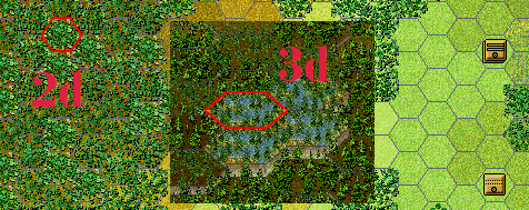
Image

I've submitted a support request to have the missing terrain levels added to the 3D files and update the program to have the 3D march, rough, blocked and targets hexes find the appropriate lines after the update. Hopefully that could be added to the next update release.

Lieutenant Colonel Derek Hampel
Fifth Infantry Brigade
Second Div., XV Corps
Army of the Tennessee

Author:  Joe Meyer [ Sun Mar 30, 2014 1:52 am ]
Post subject:  Re: HPS & JT-Overland Maps - Terrain File Conflicts (2d vs.

Derek, are these errors produced from the map editor or are they a portion of any of the existing titles? Also which map files from which games are represented in you samples?

Author:  D. Hampel [ Sun Mar 30, 2014 6:19 am ]
Post subject:  Re: HPS & JT-Overland Maps - Terrain File Conflicts (2d vs.

Hi Joe, (Gen. Meyer, Sir! <Salute>)

I've tested this example in all of the HPS and JT-Overland versions. It doesn't exist with the Talonsoft/Matrix BS series as those maps are a painted .bmp image. With the HPS and JT campaigns the maps are generate from the map files and the conflict exist if a map (standard/stock or generated) terrain exceeds the 14th level in 3d view. The example I showed above was from my large ACW scenario map (custom). As most scenarios don't go beyond level 14, the error/discrepancy isn't identified. Only when a map exceeds the level 14 would it appear.

For a real quick comparison in any of the versions, you can look at the 2DGround100 file in the map folder and see there are 28 terrain levels (the special terrain feature are located in the 2DFeatures100 file). In the 3DGround100 file there are only 14 terrain levels and then some special terrain feature hexes. Looks like the 3D file was shortened to show only 14 levels and the other special feature views/hexes were added after that....maybe to eliminate the 3DFeatures100 file or maybe the 28 levels plus the special terrain was too large of a file?

Lieutenant Colonel Derek Hampel
Fifth Infantry Brigade
Second Div., XV Corps
Army of the Tennessee

Author:  Joe Meyer [ Sun Mar 30, 2014 1:29 pm ]
Post subject:  Re: HPS & JT-Overland Maps - Terrain File Conflicts (2d vs.

Derek, you're absolutely correct. There are less levels represented in the 3D graphical files! I had not noticed this before, probably because I personally play all of my games from the 2D views.

I'm not certain, however, why the graphical ground files in 2D and 3D formats should be at variance, unless it be from a decision by the graphical designer(s) to try and keep the 3D view asthetically uncluttered. But in order to do that, the elevation data for each hex had to be unaffected by the 3D display! This is really odd, and I would like to explore it further since I was on the verge of creating a brand new, complimentary set of 3D ground files for my earlier 2D set. I hope that HPS/JTS will be able to respond to this.

Author:  S Trauth [ Tue Apr 01, 2014 5:26 am ]
Post subject:  Re: HPS & JT-Overland Maps - Terrain File Conflicts (2d vs.

The 14/28 thing presupposes that you need to have a some sort of distinction for elevation. I am not sure that is really that true in 3d. The 3d itself is the elevation can be the distinction.

However, that being said, I do know that in some series they do do some color differentiation in the 3d files as well.

Author:  Joe Meyer [ Wed Apr 02, 2014 1:04 am ]
Post subject:  Re: HPS & JT-Overland Maps - Terrain File Conflicts (2d vs.

As I stated, I'm not that familiar with gauging the elevations in the 3D display. But in the few battlefields I've examined specifically for this issue, I've had trouble in distinguishing the elevations of the opposite side down slopes where the change is gradual. When looking at the front side of the 3D display, there's no problem. But its the back side where you have to use your hex highlighter to distinguish a close elevation change, or play with the hex outline option activated.

It's kind of a deceptive thing, and if you are used to playing in 3D, as I am not, this is probably not a hard thing to overcome as one would become pretty adept at examining those backside, close elevation changes. And obviously there is a greater sense of pictorial realism imparted to the battlefield as the graphical designer strived to create a seamless effect to the display.

I don't think that JTS/HPS will go to the trouble of doubling the 3D hex displays, as they would have to change the display code data call outs. But I'm going to play around with making some alternate 3D hex files as companions for the ones I've created in 2D and see how things might look. It won't hurt to have some optional displays.

Author:  S Trauth [ Sun Apr 06, 2014 5:12 pm ]
Post subject:  Re: HPS & JT-Overland Maps - Terrain File Conflicts (2d vs.

I found that, at least in the case of 1776 (the only title that I played around with), the Campaign series files worked pretty well -when switching their hexes around in place of the stock 3D. The Campaign series being East Front, West Front, Rising Sun and I think Divided Ground (which I did not use... but probably largely used exactly the same material).

The thing is, that I think those images are copyrighted -probably to their current publisher (or possibly still to whoever owns the rights to Talonsoft) - so I was never going to be posting a mod for download. For some reason I don't think I even created screenshots ... I might have to go and do that.

The backsides of elevations (as well as where there are watercourse hexsides), would be an issue in all 3D maps I think.

Page 1 of 1 All times are UTC - 5 hours
Powered by phpBB® Forum Software © phpBB Group
https://www.phpbb.com/