American Civil War Game Club (ACWGC)
http://www.wargame.ch/board/acwgc/

JTS vs. WDS Gettysburg Map - Which is Right?
http://www.wargame.ch/board/acwgc/viewtopic.php?f=4&t=23461
Page 1 of 1

Author:  Blake [ Tue Oct 24, 2023 10:01 am ]
Post subject:  JTS vs. WDS Gettysburg Map - Which is Right?

You know, you play a game a thousand times and then suddenly something hits you that you never intelligently thought of before.

Looking at the old Matrix image of Little Round Top and Devil's Den, you see there are no marshy areas between those two points:

Image


But if you look at the WDS version, there are marshy areas between those two points:
Image


Having visited Gettysburg a number of times in the summer, it is bone dry as far as I recall. And even looking at photos from myself and others online, I don't see any real "marsh" areas around the Devil's Den.
Image


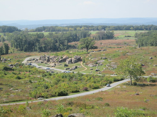
I admit I could be wrong as I don't visit the battlefield enough to really know what the terrain between those points looks like in July. But I do wonder which map interpretation is right. In the modern photo there is more vegetation than usual near the Devil's Den but I don't know if that means "marsh" or not.

I could go back and read up on the battle and look for specific quotes and such. But does anyone have any input off the top of their heads as to all of this? Is there a marsh between these two points to justify the five-hex long marsh in the WDS game?

Speaking as a Johnny Reb, that marsh is a pain in the butt when you attack on that flank. Should it really be there? If so, no problem, cool. But it might be one of those judgment calls that JTS said "no" the first time but "yes" the second time. There has to be a backstory.

Author:  Mike Letus [ Tue Oct 24, 2023 12:55 pm ]
Post subject:  Re: JTS vs. WDS Gettysburg Map - Which is Right?

Blake wrote:

Speaking as a Johnny Reb, that marsh is a pain in the butt when you attack on that flank.


As a Billy Yank I think that the marsh not only belongs there, but it also needs to be stocked with gators, leaches, piranhas and anything else that'll slow Johnny Reb down!!!! :-}

Author:  Quaama [ Tue Oct 24, 2023 2:57 pm ]
Post subject:  Re: JTS vs. WDS Gettysburg Map - Which is Right?

I tend to think the marsh should be there. The creek on the maps is known as Plum Run. The three hexes of marsh north of the ones near Devil's Den should probably not be there.

I found this reference (https://warfarehistorynetwork.com/what-happened-at-the-devils-den-at-the-battle-of-gettysburg/) which says:
"Seeing the logic of Smith’s decision to cover the Devil’s Den flank, Ward sent off nine of the 10 companies of the 4th Maine under Colonel Elijah Walker to bolster Smith’s two detached guns. Picking their way down into the low marshy swale, these men formed a rough line in the midst of the boulders located on the northern rim of Devil’s Den that stretched across to the far side of Plum Run."

Also, and more definitive, is 'Elliot's map' of Gettysburg (https://www.loc.gov/item/99447500/). Specifically drafted in 1863 to show the locations of the veteran's graves it also shows some other features. If you enlarge the map you can see Plum Run to the east of Devil's Den and alongside the creek there you can see map icons indicating marsh. [There are a lot of graves west of the creek, so many that almost every step someone takes on the ground near there is the resting place of a veteran.]
About a quarter of a mile further south (about 4 hexes in the game) along the creek Elliot has shown a more extensive marsh running along the creek; there are no marsh hexes on the WDS map in that area (not one!).

[Edit note: Other than in the article quote (which was accurate), the words 'Marsh Creek' were replaced with 'Plum Run' to give the creek it's correct name (I must have been too preoccupied with marshes, LOL).]

Author:  Michael Barycki [ Tue Oct 24, 2023 5:21 pm ]
Post subject:  Re: JTS vs. WDS Gettysburg Map - Which is Right?

Plum Run has historically been notorious for flooding. Whenever a big rain comes, even today, it can get bad. At the moment there's a huge issue because the park service allowed beavers to construct dams there and multiply so there is a big lake in that area now. But from a historical context, I think they are trying to replicate the fact that it will flood and at times (maybe even in early July '63) the area is a bit wet and marshy after rains.

The marshy Plum Run 3-hex plot to the north of the Wheatfield Road is still like that today (you can go here to see a google view of that area https://www.google.com/maps/@39.7979187,-77.2386998,284m/data=!3m1!1e3?entry=ttu)

Author:  Quaama [ Tue Oct 24, 2023 6:10 pm ]
Post subject:  Re: JTS vs. WDS Gettysburg Map - Which is Right?

Michael Barycki wrote:
Plum Run has historically been notorious for flooding. Whenever a big rain comes, even today, it can get bad. At the moment there's a huge issue because the park service allowed beavers to construct dams there and multiply so there is a big lake in that area now. But from a historical context, I think they are trying to replicate the fact that it will flood and at times (maybe even in early July '63) the area is a bit wet and marshy after rains.

The marshy Plum Run 3-hex plot to the north of the Wheatfield Road is still like that today (you can go here to see a google view of that area https://www.google.com/maps/@39.7979187,-77.2386998,284m/data=!3m1!1e3?entry=ttu)


That's very good information.
I'm thinking Elliot showed no marsh as it was not present when he was drafting his map (and it was not a map for topographical purposes). Some more information can be found here (http://www.gdg.org/Research/Other%20Documents/Newspaper%20Clippings/v6pt1l.html & https://www.theweathernetwork.com/en/news/weather/severe/this-day-in-weather-history-july-1-1863-the-battle-of-gettysburg). It seems that there had been rain prior to the battle and the thunderstorm on Day 3.
The second link says, in part:
"The third day of the Battle started with significant cloud cover but a lot of it cleared by the afternoon. However, the cloud that didn't clear happened to be the "massive thunder-cloud of summer." At around 6 p.m. EDT, a thunderstorm developed. "The thunder seemed tame, after the artillery firing of the afternoon," wrote Rev. Dr. Jacobs.
...
And on the third day of the Battle, many of the wounded were still lying in the field. Those who were laying in areas near the Plum Run Creek drowned."

Author:  Blake [ Tue Oct 24, 2023 6:49 pm ]
Post subject:  Re: JTS vs. WDS Gettysburg Map - Which is Right?

Good info and research! Looks like the WDS map got it right. Much to my consternation as I attack the Devil's Den.

Author:  mihalik [ Tue Oct 24, 2023 6:53 pm ]
Post subject:  Re: JTS vs. WDS Gettysburg Map - Which is Right?

I checked the index in Pfanz's book on the second day for entries on Plum Run. Apparently the going was tougher than crossing a normal stream, and at least once ankle-deep mud was mentioned. So a marsh designation is probably warranted in places along Plum Run, but it was difficult to determine exactly where.

Author:  L.P. Smith [ Wed Oct 25, 2023 9:23 pm ]
Post subject:  Re: JTS vs. WDS Gettysburg Map - Which is Right?

Yeah, the Plum Run valley is a bit soggy. The NPS even has walking boards in the area around Devils Den because the ground is often quite saturated.

Author:  krmiller_usa [ Fri Oct 27, 2023 7:29 am ]
Post subject:  Re: JTS vs. WDS Gettysburg Map - Which is Right?

Was a member of the FNPG for over 25 years and attended Musters twice a year at Gettysburg most years going on guided walks in various types of weather in the spring and fall.
I can recall several tours where we hit very soggy/muddy conditions, specifically one around the area of Scales advance on the first day and another in the area of Plum Run.
According to the weather charts for Gettysburg game there was a good bit of rain in the last week of June 1863.

I recall my grandmother's saying whenever someone told her they would see her tomorrow, "Good Lord willing and the creek don't rise."
Born on a farm in Ohio in 1900 the road to the farmhouse was a half mile or so and still dirt when we would visit my great aunt there in the 50's and it went through a dip in the ground with a creek that could vary in width and depth depending on the weather.

Another thing to consider is the army used the battlefield as a training ground for a number of years and one of the guides pointed out some of what they did changed the slope of the ground in some areas.

Author:  Bill Peters [ Sun Oct 29, 2023 4:33 pm ]
Post subject:  Re: JTS vs. WDS Gettysburg Map - Which is Right?

I found in my discussion with the late Doug Strickler that it fruitless to disagree with him on his decisions for the game. He zinged me good with the II Corps topic where I wondered why the corps arrives on the first day. His answer was spot on saying that they were there but when the hills were not in danger they were told to go into bivouac for the night. Good ole Doug knew his stuff. <THUMBSUP>

I still think that the Union supply train should arrive sooner but oh well ... as the Yank I have never had an ammo problem. ROFL

Page 1 of 1 All times are UTC - 5 hours
Powered by phpBB® Forum Software © phpBB Group
https://www.phpbb.com/