Where on the map would it be, between the Mill and Z.Taney?
Maj.Gen. Drex Ringbloom,
Commanding 2nd Div, "Corcoran's Legion", VIII Corps
Army of the Shenandoah

| American Civil War Game Club (ACWGC) http://www.wargame.ch/board/acwgc/ |
|
| Mill Pond near Culp's Hill http://www.wargame.ch/board/acwgc/viewtopic.php?f=4&t=14641 |
Page 1 of 1 |
| Author: | Al Amos [ Thu Feb 11, 2010 4:52 am ] |
| Post subject: | Mill Pond near Culp's Hill |
I'm watching Battlefield Detectives: Gettysburg, on the History Channel. They just finished talking about the defence of Culp's Hill. They asked why the rebs didn't try to go around it to the east to get to the Baltimore Pike. It turns out there was a mill pond attached to Rock Creek. It was an impassable object. Sounds like it would've be one to three hexes big. Any chance we can get that on the map? It would change play a great deal. MG Al "Ambushed" Amos, Commanding Officer 1st Div, I Corps, AoP, USA |
|
| Author: | Drex [ Thu Feb 11, 2010 5:08 am ] |
| Post subject: | |
Where on the map would it be, between the Mill and Z.Taney? Maj.Gen. Drex Ringbloom, Commanding 2nd Div, "Corcoran's Legion", VIII Corps Army of the Shenandoah
|
|
| Author: | Don Golen [ Thu Feb 11, 2010 5:34 am ] |
| Post subject: | |
It's a magical Union controlled hex that becomes active as soon as a Rebel Division steps into it. At that point you bring up General Howard's command box and trigger the Magical pond event. Boom! Division gone, scenic waterfront created. (Soon to be the home of the Gettysburg Mill Pond Casino and Offtrack Betting Parlor).[:p] In all seriousness, this pond concept has been around for awhile. I'm not sure if they have definitively proven it's existance at the time of the battle.[?] General Don Golen I Corps /Army of the Potomac "The Iron Corp" 
|
|
| Author: | Drex [ Thu Feb 11, 2010 6:17 am ] |
| Post subject: | |
Looking at the Military Atlas of the Civil War which has prepared Maps used at the time(plates 40,pg121 & 43,pg126, no pond is shown, although the sawmill would probably have one. Maybe it was just a thickened portion of Rock Creek. Maj.Gen. Drex Ringbloom, Commanding 2nd Div, "Corcoran's Legion", VIII Corps Army of the Shenandoah
|
|
| Author: | Drex [ Thu Feb 11, 2010 6:32 am ] |
| Post subject: | |
Okay, I found photos of the pond which was created by the McAllister mill dam. 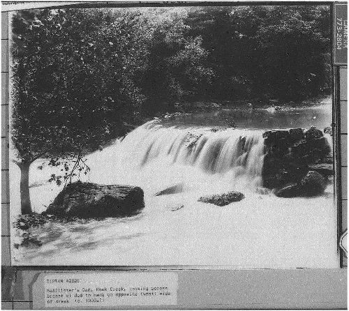 , ,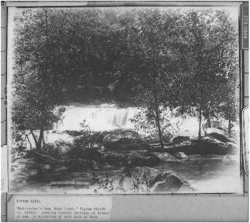 . .
This pond was 60-80 ft wide and 6-8 ft deep and mostly filled the nearly 1/2 mile gap between 13th New Jersey and Neill's Brigade(Colgrove's Report,OR,series I,Vol.27,pg.812) The dam was destroyed by flood in 1870. Maj.Gen. Drex Ringbloom, Commanding 2nd Div, "Corcoran's Legion", VIII Corps Army of the Shenandoah
|
|
| Author: | Drex [ Thu Feb 11, 2010 6:44 am ] |
| Post subject: | |
David: I wasn't finished. I added additional info to the picts:) Maj.Gen. Drex Ringbloom, Commanding 2nd Div, "Corcoran's Legion", VIII Corps Army of the Shenandoah
|
|
| Author: | KWhitehead [ Thu Feb 11, 2010 8:06 am ] |
| Post subject: | |
The Gettysburg Companion shows a enclosed area of water next to McAllisters but doesn't identify it. The area is already a very obstructed area and well south of Johnson's position. I doubt it represented a blocking area to Johnson since he never approached it. The usual reference to turning the position is that Steuart could have moved SE through the clear gap between Culp's Hill and Sheep Hill following Sprangler Spring to the Baltimore Pike and behind Culp's Hill. Main problem was the Ruger's Division was along the Pike near Power Hill. But I am not sure of at what times troops were present. But doing anything but what Johnson did is probably an improvement. LG. Kennon Whitehead Chatham Grays 2/3/IV AoM (CSA) |
|
| Author: | Al Amos [ Thu Feb 11, 2010 2:12 pm ] |
| Post subject: | |
60-80 ft wide, 6-8ft deep nearly 1/2 mile in length, hmmmm.... Perhaps use the impassible creek hexside for that part of Rock Creek? MG Al "Ambushed" Amos, Commanding Officer 1st Div, I Corps, AoP, USA |
|
| Page 1 of 1 | All times are UTC - 5 hours |
| Powered by phpBB® Forum Software © phpBB Group https://www.phpbb.com/ |
|