Gents,
Now that I'm able to use the map editor again and have experimented with creating some new maps, I've notice that a conflict still exist with the Map folder terrain files (2DGround50 &2DGround100) vs. the (3DGround50 and 3DGround100). The 2D files contain 28 levels of terrain. The 3D files contain 14 levels of terrain then convert to special terrain hexes (marsh, rough, blocked or target view). I made a map which contains 21 different levels and any hex with terrain at level 15 or above show funny terrain images in the 3D view. Under the 2d views there is no problem. I also noticed in the jump map view you can see the distorted hexes as well. This leads me to believe that there was an oversight and the 3D file was stopped at 14 lines and should have continued to 28 terrain levels.
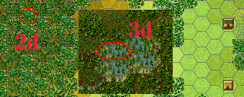
Here is a sample of the 2d view at level 15 with normal terrain and woods. The 3d view shows it as a marsh hex with woods.....
I've submitted a support request to have the missing terrain levels added to the 3D files and update the program to have the 3D march, rough, blocked and targets hexes find the appropriate lines after the update. Hopefully that could be added to the next update release.
Lieutenant Colonel Derek Hampel
Fifth Infantry Brigade
Second Div., XV Corps
Army of the Tennessee